GPXSee
GPS log file viewer and analyzer with support for GPX, TCX, KML, FIT, IGC, NMEA, SLF, SML, LOC, GPI, GeoJSON and OziExplorer files.
GPXSee is a Qt-based GPS log file viewer and analyzer that supports all common GPS log file formats. The project is written primarily in C++, distributed under the GNU General Public License v3.0 license, first published in 2015. It has gained significant community traction with 1,212 stars and 155 forks on GitHub. Key topics include: coros, fit, garmin, geojson, geotiff.
GPXSee
GPXSee is a Qt-based GPS log file viewer and analyzer that supports all common
GPS log file formats.
Features
- Opens GPX, TCX, FIT, KML, NMEA, IGC, CUP, SIGMA SLF, Suunto SML, LOC, GeoJSON,
OziExplorer (PLT, RTE, WPT), Garmin GPI&CSV, TomTom OV2&ITN, ONmove OMD/GHP,
TwoNav (TRK, RTE, WPT), GPSDump WPT, Velocitek VTK, Vakaros VKX, GoPro GPMF
videos, DJI videos, Sony RTMD videos, Google CAMM videos,
Novatek/VIOFO/Blackvue/Vantrue/70mai dashcam videos and geotagged JPEG/MP4
files. - Opens geo URIs (RFC 5870).
- User-definable online maps (OpenStreetMap/Google tiles, WMTS, WMS, TMS,
QuadTiles). - Offline maps (MBTiles, PMTiles, OziExplorer maps, TrekBuddy maps/atlases,
Garmin IMG/GMAP & JNX maps, TwoNav RMaps, GeoTIFF images, BSB charts,
ENC charts, KMZ maps, AlpineQuest maps, Locus/OsmAnd/RMaps SQLite maps,
Mapsforge vector maps, QCT maps, GEMF maps, Osmdroid SQLite maps, Orux maps,
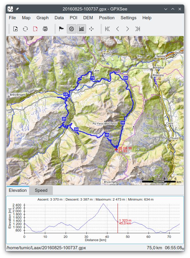
COROS maps, ESRI World-File georeferenced images). - Elevation, speed, heart rate, cadence, power, temperature and gear ratio/shifts
graphs. - Support for DEM files (SRTM HGT).
- Support for multiple tracks in one view.
- Support for POI files.
- Print/export to PDF/PNG.
- Full-screen mode.
- HiDPI/Retina displays & maps support.
- Real-time GPS position.
- Windows, macOS, Linux and Android builds.
Build
Prerequisites
- Qt5 >= 5.15 or Qt6 >= 6.2 (Android builds require Qt6)
- Zlib (the Qt-provided one is used where the platform does not provide its own)
Steps
shelllrelease gpxsee.pro qmake gpxsee.pro make # nmake on Windows
Download
Changelog
Homepage
Maps
Translations
GPXSee uses Weblate
for translations.
License
GPXSee is licensed under GPL-3.0 (only). However, some 3rd party parts are using
different, GPL compatible, licenses:
- Icons8 Flat Color Icons - MIT
- Papirus icons - GPLv3
- Mapbox Maki icons - CC0
- Map Icons Collection - CC BY SA 3.0
- RTree implementation - Public domain
- Albers, Geocentric,
LCC, Mercator,
Polar Stereographic,
Polyconic and
Transverse Mercator projections - NIMA
Source Code Disclaimer - Projection parameters CSV files - BSD/EPSG/Public domain
- OSM Liberty and Protomaps
MVT styles - BSD
Contributors
Showing top 12 contributors by commit count.


Related Repositories

cygnusb/coros-mcp
MCP server for AI assistants to read and manage Coros fitness data: sleep, HRV, daily metrics, activities, and structured workouts via the unofficial Coros API

VanIseghemThomas/OpenCortex
A project that opens your Quad Cortex for homebrew software

xballoy/coros-api
Bulk export your Coros activities to FIT to import them in a 3rd party